Support on
the road Navigation data to create the best Routing experience and
arrived with Accurate destination.
Full offline road navigation map data that strive for excellent
navigation experience and ensure precisely arrival of the
destination.
Offline
Navigation Data
Best Coverage
Map In ASEAN
Global
Navigation Partners
Accurate Map
Data
Customizable
Map
Best Support
Service
Map for Navigation
Map for Navigation, MapFusion GPS Navigation Map has been widely trusted and accepted in
the industry of GPS car navigation devices for more than 10 years. It is the most
accurate and detailed GPS navigation system in Thailand. Users can expect every
journey to be smooth and safe. It is compatible with a variety of devices including
car navigation devices, screen displays, and map navigation applications etc. Our
GPS system is trusted by leading GPS navigator companies such as GARMIN, SPEEDNAVIl
and leading car dealers such as MG, TOYOTA, ISUZU, MITSHUBISHI, NISSAN etc.
Function
& Attribute
Maps for Navigation are divided into 7 types as follows:
POI Location
Address Data
Address
point. The details of house no. location
Landmark The
details of interesting places, in form of point
POI
Naming The other name of landmark for
searching supported
Village
Point The details of village location, in
form of point
Administrative Boundaries Data
Admin
Line The line of Thailand administrative
boundary
Admin
Point The location of Thailand
administrative boundary
Admin
Poly The details of Thailand
administrative boundary
Country The
details of country and sea boundary
Municipal The
details of Thailand municipal boundary
Public
Area The details of public area, in form
of polygon
Hazard
Warning and Road Sign Data
Sign
Post The details of sign post, in form of
point Turntable The
details of the turn restriction sign which has two dimensional
routes HW
Marker The details of highway location
marker, in form of point Direction
Sign The details of direction sign, in
form of point Lane
Info The details of lane information, in
form of point Bifurcation The
details of bifurcation (Y shape junction), in form of
point TollExit The
details of the Toll Exit which has point of Expressway
Exit. Junctionview The
details of the junction view which has virtual images to navigate
correctly to destinations
Optional Data
for Landmark and Road
Landmark
Break Name of POI with break word rules
for searching system.
Landmark
Disp Name of POI with abbreviation for
Display on device
Landmark
Phoneme Name of POI with symbol instead
sounds for Navigation system.
Road
Break Name of Road with break word rules
for searching system.
Road
Disp Name of Road with abbreviation for
Display on device.
Road
Phoneme Name of Road with symbol instead
sounds for Navigation system.
Environment
Data
National
Park The details of national park data
Hydrology The
details of the hydrology data
Airport
Runway The details of airport runway data
Building and
3D Footprint Data
Building The
details of building data, in form of polygon
Model 3D The
details of 3D Model Building.
Building and 3D Footprint
Data
Intersection The
position of intersection, also name or signal code
Junction The
position at the end of road that has many types of position such as
junction point with traffic signal, traffic signal with red light
camera installation, border crossing, railway crossing, toll booth
L trans The
details of road transportation data which has two dimensional route
Route
Table The details of bus line information
table and linked to the bus route and the bus stop
Masstransit The
details of the mass transits data which has two dimensional route
Railway The
details of the railway data which has two dimensional route
Bus Stop The
details of bus stop data, in form of point
Bus
Route The details of public
transportation data, in form of line
Airport
Info The details of airport position
data, in form of point
GT TMC The
details of traffic message channel
Navigation
Point The details of the navigation point
which has position of entrance place.
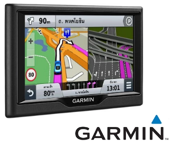
MapFusion Map
Portable Navigation Device :
PND
Consult with
our experts
Have a question, or don’t know where to begin? Send us your inquiry
today! Our team is readily available to provide help and support
wherever possible.